Cyclone Emnati flood forecasts guide Madagascar aid response
25 February 2022

Flood forecast analysis by leading scientists are supporting UK government aid efforts in Madagascar, after Cyclone Emnati became the third tropical cyclone to hit the country in five weeks.
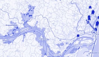
Scientists at the University of Reading, HR Wallingford, the European Centre for Medium-range Weather Forecasts (ECMWF), University of Bristol and Fathom have been providing pre-event data on which areas and rivers will be worst hit by rainfall and flooding to assist the UK Foreign, Commonwealth and Development Office (FCDO) in getting aid to communities most in danger.
Classified as a Category 3 cyclone, Emnati made landfall in Madagascar on Wednesday 23 February, bringing 115mph winds, with gusts of up to 140mph, and heavy rainfall.
It is forecasted to follow the same path as Storm Batsirai, which hit the region one week earlier, killing more than 100 people and displacing around 30,000.
Professor Hannah Cloke, a hydrologist at the University of Reading and a member of the team producing the reports, said: “Emnati makes the damaging storms we saw in the UK last week look tame in comparison. Regions of Madagascar have seen winds of up to 100 miles per hour, and torrential rainfall pouring into rivers already swollen by other recent cyclones meant that catastrophic flooding was inevitable.
“While loss of life is sadly unavoidable in storms of this scale, reacting to forecasts and reports like ours helps agencies get aid to the worst-hit areas fast, and allow evacuations before communities are cut off by flooding.
“These forecasts are worthless if they are not acted upon. Lives depend on the decisions made during storms like this, and the science is there to inform them.”
The emergency bulletin, issued on 21 February, predicted that southeast Madagascar would experience rainfall totals of more than 150mm during 22-23 February, with heavily impacted areas potentially receiving up to 600mm of rain during this period.
Analysis of storm surge was also expected to affect low-lying districts close to the coast, including Nosy Varika, Mahanroro, Mananjary and Manakara-Sud.
The reports are produced using the Global Flood Awareness System (GloFAS), jointly developed by ECMWF and the European Commission, and operated from Reading as part of the European Copernicus Emergency Management Service, which provides an overview of flooding events over the next 30 days.
The ongoing collaboration between ECMWF, Copernicus and leading UK scientists has helped to provide governments and aid agencies worldwide with potentially life-saving forecasts of floods.
Flood forecasting reports were previously provided on request of FCDO following Cyclone Idai in March 2019, and Hurricanes Eta and Iota in Central America in November 2020.

